 Karibuni Safaris has initiated a community telecentre project in Lwakhakha to train the community in computer use and thus bridge the digital divide. This is part of our pro-poor tourism initiatives to ensure the local community benefits from fair traded safaris. Having embarked on the community telecentre project, we recently took stock of attractions and activities in which volunteers could engage to pass time in-between teaching children at Lwakhakha telecentre.
 Tourist attractions around Lwakhakha included the Sono water intake from where Tororo town gets water and rock bridge over river Lwakhakha wide enough for 5 cars to traverse at the same time. This bridge connects Uganda to Kenya and is called “daragi ya mungu” literally translated as God’s Bridge. The main activity is subsistence farming, with the use of donkeys to transport produce and irrigate on a small extent. This area is famous for coffee, beans, onions, tomatoes cabbages etc and is ideal for a cultural experience during the circumcision ceremonies in even years.

 On two prior trips to Lwakhakha I had seen a stunning waterfall on the slopes of Namusindwa Ridge, but due to limited time was unable explore the site. On my third trip I was determined to visit Laso waterfalls, get a description, pictures and find out how to get there and away. Laso Falls could be a second route to entertain volunteers combined with a cultural experience on mountain bikes. We set off early so as to get to the waterfalls and away before it would become very hot. Our first hitch; breakfast wasn’t ready and we improvised with doughnuts, coca cola and mineral water arriving at Bumalye at 8 am.
  We drove from to Bupoto 8 kms and turned left driving another 8 kms to the trail head at Bumalye. We parked the car at Bumalye and started the hike. In the school compound, we found 3 donkeys and learnt that they are the preferred means of transport due to the steep terrain.
The hike was easy at first but as the gradient got steeper (close to about 70 degrees) as we approached the waterfalls, I started feeling dizzy and gave up the hike feeling disappointed and dejected.My guide John Kimwanga continued to the base of the waterfalls the rest of the story is his personal experience and the images he took.
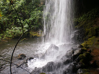
River Laso emerges over a cliff on Namusindwa Ridge, from the catchment area in Mt Elgon National Park. The water gorges its way atop of Namusindwa Ridge before dropping approximately 260 feet; it splits into 3 falls the one on the extreme right (carrying the bulk of the water) terminating at bottom. The other two waterfalls simply jet-off the cliff for the last 25 feet, in a misty chilly spray making a spectacle that would marvel and inspire any architect.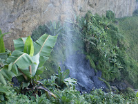

 Kimwanga observes “When you get to the base of the falls, you are literally out of breath and sweating as the hike gets very steep in the last 20 feet. I knew I had arrived when I was hit by a very cold shower and feared that I may suffer from hypothermia. Water jets off the cliff coming down in a hissing misty shower which is extremely cold. In a strange way, the cold was welcome after the strenuous hike. This waterfalls, is used as a shrine for (Wele Masaha) the water deity by the local people adding to my suspicion that this maybe sacred ground and therefore dangerous”.
 With the combination of a slippery walk way and ice-cold water, I could not get to the base of the waterfalls. I took pictures about 30 metres from the base and left in a hurry before the biting cold started to take effect on my body. To enjoy the spectacular views at the top one needs warm and water proof clothing. Fortunately there is natural terrace which can hold 50 people. Laso falls has not been developed for tourism and is rarely visited. A stairway for the last 10 feet would ease the ascent, but for the time being, Laso is not for the faint hearted.
We are planning a cycling tour, starting in Mbale to Laso Falls, crossing the border into Kenya and proceeding to Kitale visit the museum, Delta Camp to see Rhinos and the famed underground Elephants and Bat caves in Mt Elgon National Park. Then, cycle to Suam cross back into Uganda for a night stop, ride to Kapwai Cottages for a cozy room, hike the forest exploration trails around the centre the next day. The afternoon is then spent, hiking the 3 sister falls, abseiling or trout fishing on Sipi River. The team the rides to Sisiyi Falls or alternatively visit Bulago area and pitch camp for the night. Set off early to Jinja for white water rafting, kayaking drive directly to airport for departure flight. This “Tour de Elgon” takes 12-14 days giving you, a cultural expose, living in budget eco-lodges on low impact transport.


 "Mother Nature" has combined the ancient rocks adjacent to sparkling waterfalls in a dark canopy of shrubs making a good Eco-system for small primates like the black and white colubus monkeys and bird species such as


